Saturday, Sep 15, 2012
After more than a year hiatus, I am now back on the trails. After searching on Meetup for hiking groups near my new home in Valencia, Santa Clarita, I saw two groups that seemed a great fit. Last weekend, I hiked Goody Koontz peak with the Valencia Hiking Crew which was fantastic, and this weekend, its time to check out the Santa Clarita Community Hiking Meetup. We are going to hike to the Punchbowls in Santa Paula Canyon about an hour away. A hike along a creek ending in water pools seems like the perfect way to spend a Saturday with temperatures soaring to 105 degrees.

Its morning 6:30 and I am heading out to the carpool spot. I notice my Garmin G60cx (hiking GPS) lying on my table with a battery missing. I am already late and don't want to miss the carpool again this week, and who needs a GPS when you are not leading a hike. I leave it and head to the carpool location. Just make it on time. Dave, the organizer is very warm and welcomes me to the group. I have known organizers who don't care to say hi and so this is a great start. We take two cars (mine and Dave's) and head to the trail head about an hour away just outside St. Thomas College in Santa Paula. We are on the trail by around 8 am. The weather's pleasant and there's plenty of shade. It's one of the most beautiful hikes I have done. Reminded me of Fish Canyon Narrows. Creek, shade, not too much elevation gain, nice people, good conversation, pretty views. Perfect. We stop by the waterfall to take pictures. Its a small waterfall but beautiful. There is a lot of graffiti everywhere along the trail and more so here at the waterfall, which is very sad, but the landscape is still pretty. Ours is the only group there considering its still relatively early in the morning for college kids who seem to form the majority of the hikers on this trail, and of course its a hot day. We then make it to our destination which is another amazing spot, with a pretty pool (the punch bowl) and water trickling from above. Lunch break, and lots of photos. Engelbert and I get into the pool, parts of which are almost chest deep. Well, at least for me. After a relaxing break we are refreshed, and glad we came for the hike. It is pretty close to where we live and so beautiful and peaceful. Kathy mentions she could sit there for ever. And I can't agree more.


Its getting close to noon now and we better start heading back for its going to get really hot. We head back. Just after about 15 minutes of hiking, I realize I forgot my sunglasses at our lunch spot. Darn! Should I forget about it? Well, we are not too far from there and I am a seasoned hiker. The fact that I was once affectionately nicknamed "King Lost" does not cross my mind. I can run back and get it. I should be able to catch up with the rest of the crew in no time. So I decide to turn back. Engerlbert offers to come with me and I say "No. You carry on. I will join you guys. I will be fine." I wonder if I should leave my backpack just so I can make more speed. But, he says "No just take it with you.". I decide that's a good idea. I start running back. He calls me and suggests we exchange phone numbers. That sounds like a good idea. But I don't think we will need to. I am just 15 minutes away from the lunch spot and my sunglasses. I am going to be running back so I should be able to catch up with the group in no time. Engelbert tries to call me but there is no reception. He says you will get a missed call from me when we have reception and then we will have each others numbers. Sounds good. I won't need it anyway, I tell myself and then I run back.
As I run back I notice that there are other trails that do criss-cross which I had noticed earlier in the day but wasn't careful to keep track, since I was busy in conversation, knowing Dave had it all figured out, which he had. But I just need to retrace our steps that we took just a few minutes ago. How hard can that be? I continue running. I see the big log across the trail, that I had noticed. Great. Continue running, then the trail branches. I am pretty sure its this one. I continue running. A few more turns. Hmm. I have been running for a longer distance now than how far the lunch spot should have been. I must have taken a wrong turn. I go back try another trail. No lunch spot. This is no good. I should head back. I remember Dave mentioning that one of the trails leads to Frazier park which is about 40 miles away! I don't want to end up there! So I decide to head back. Screw the sunglasses. They were old and not expensive. I can get another pair. I start tracing back my steps to get to where the rest of my group went. Wait, where is the trail? I panic. I search around a bit and find the trail. Phew! I start hiking back. I come to the log across the trail. Great! All's good. Pretty straightforward from now. I keep hiking. A few more trails intersect. And I go the way I think we went. I am at a spot where we had stopped to take pictures. Remember it distinctly. Okay. Good. I keep going. The trail diverges – one goes up the other down. I decide to take the one that goes down. It reaches the creek. But wait. We did not go to the creek in this section. Let me go back up and try the other branch that goes up. I go up that branch and it leads me along the creek but higher. This seems more like the trail we took. But... I don't remember this section. I keep going. The trail ends. Dead end??? I panic again. I need to call Engelbert. I pick up my cell phone. No signal. I don't even have Engelbert's number because I have had no reception and haven't got his missed call. I am a little worried. Less so for myself than to have to delay the rest of the group. I am sure they have other plans for the day. I don't want to hold them up. I move around and get one phone connection bar. Thank goodness! I try calling Sudarshan so I can ask him to look up on meetup.com and see if he can get any of my group member's phone number. May be Dave's? The call doesn't go through. The one bar is Verizon's evil way of tricking you. You need more than one to get your call through. Alright let me try going back down to the creek and may be I will see a path to the trail. I go down and start walking up the creek. I am walking upstream. That's interesting. I remember that the water was flowing downstream at the lunch spot. But then I am 100 percent sure I am walking in the opposite direction. May be the water flows downstream from 2 different parts and meets at the waterfall. That is very possible. I walk up further. I see that there is still some graffiti on the walls. Good. This is hiker country. Never thought I will be happy seeing the graffiti but I was. I walk up further and notice that there seems to be a trail going up on the canyon. May be that's where I need to be. I start climbing the canyon. Loose soil. I slip. But I am on all fours and climbing. I make it about midway but there doesn't seem to be a trail. I decide to go back to the creek. I simply sit on my back and slide down. I get a few scratches. Nothing major. Great. I am back at the creek. I decide to go back to the point where I was sure we had taken pictures. I am back at the point. I try the trail that goes up from there again. Reach the same dead end as before. Hmm. I am starting to get worried. I am back at the photo point again. I decide to go back to where the log is which is further back towards our lunch spot. I try to trace back my steps and reach the photo point again. What do I do? I wander around everywhere and then come back to the photo point. Just then, I receive a couple of messages and a missed call from Engelbert which he had left some time ago. Great. It is around 1:15. I text him back. The message doesn't go through. I try calling. He answers but can't hear me. Then I loose connection again. Frustrating! Just then I see a bunch of college hikers on the trail! Yay!!! My saviors. One of the guys shows me what trail to take. He says take the trail and follow the creek all the way up to the college. Great. I am back on track!

I hike down the trail he showed me and I hit the creek. I start hiking up the creek. I am hiking upstream. But then I bring my two streams meeting at the waterfall logic again. And I continue. After hiking for some distance, I don't see any more graffiti. Hmm. That is surprising. The trail to the college should be filled with graffiti like elsewhere. But then I convince myself that the actual trail is running parallel to the water while I am walking right in the water. Hence the graffiti must be on the trail and not in the creek. I keep hiking. I am now going under trees, running through water where it lets me, climbing up little water falls. My balance is good and I am very good at jumping and climbing over rocks. Also I have done water hikes before so I know where to step, where not to and where to go on land if the water is too slippery. It is all very beautiful and quiet where I am hiking but I am not in the mood to appreciate the landscape. I want to get to my group. I text Engelbret that I will meet them at the college and I am taking a different trail. That goes through after some time. Good. I keep going. I am reminded of the movie 127 hours. Of course. What if I sprain my ankle jumping over rocks? What if I am bitten by a snake? What if I fall and hurt myself? What if... what if... At least there are no lions or tigers in this part of the world. I am grateful for that. Or alligators in the water. I am fully aware that the rest of my group must be starting to get worried. I have been in that situation at Zion when Ryan, Ni and Shelly were lost. In fact, they must be more worried than me because they don't know if I am okay. I only hope my text message has actually reached them. After some more hiking, I almost don't see any human impact. Something is definitely wrong. But I convince myself that it will all be fine. I need to hike up the creek and the college will be there. That's what the guy told me. I am hoping that I am not wrong for I don't want to trace my way back. My hope is convincing me to keep going and that I am right. It is a vicious circle. I message Engelbret that I am going upstream and N and ask him if that seems correct. My iphone compass tells me that I am going Northish. But then I am following the creek and it twists and turns. I look at the sun. It looks like I am going east. Hmm. That seems weird. My message goes through after a while. I keep stopping, trying to get connection. I am getting physically tired now. This is not good. I check my water supplies. I still have some left. Good. Earlier I had thought I had brought too much water and was simply carrying dead weight. But now I am glad I did. No water and that's the end. I can't drink the stream water without filtering and I don't have a filter. I get a message from Engelbert. Go downstream. Southwest. Boy. That sounds screwed up. I am losing hope. I am tired. I am stressed. He messages me asking me my location. Thanks to the iPhone, I message him back my location. He messages me asking me to go back. That I have followed the wrong stream. That the rest of the group is at the college. He and Dave are coming back to get me. Not to drink the water. And to not worry. He asks me if they should call Search and Rescue, and I say no. Time is around 3 pm.
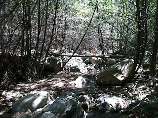
I take some Gu and start running back. I must have come around 1.5-2 miles from the waterfall, from where I started hiking along the creek upstream. Now that I know I need to get back, there is no point wasting time. I make good speed. I hop on rocks, wade through the stream, climb down little waterfalls. I just want to get back as quickly as I can. My plan is to go to the waterfall near the photo point and wait for Dave and Engelbert there since that is a point that they know about and I can tell them to find me there. Just as I near the waterfall, I meet two college kids, Jason and Jennifer. I am very happy to see them! At last human life! I ask them how far the waterfall is and they tell me its right round the corner, less than 5 minutes away. Great! I tell them my story and they tell me that they are heading back to the college too and can show me how to get there. But I know Dave and Engelbert are coming to get me and I don't want to miss them. But on second thought I realize that its going to take them a long time to get to the waterfall and hence I should go with these two and message Dave and Engelbert about my plans. I follow the two and we take a trail up from the creek. If I was 5 minutes late, I would have missed these two. I am glad I was there right on time. After following the trail for a bit, we come to an opening, a campsite that I had seen earlier in the day on our way up. Fantastic! I am saved. I thank Jason and Jennifer and I start running up the trail which is now pretty wide and clear. I meet a few other hikers along and confirm with them that this trail leads to the college. After some time, I see Dave and Engelbert! What a relief! I am so happy to see them. They have water for me which is great since my own supplies have run out. We take a break and then head back. After about 45 minutes of hiking, we are back at my car at around 5 pm and at the end of a crazy adventure. It was very nice of Dave and Engelbert to have come back to get me. If not for Engelbert's suggestion earlier that I take my backpack with me and that we exchange phone numbers, I might still be in the woods of Santa Paula Canyon Punchbowls!


